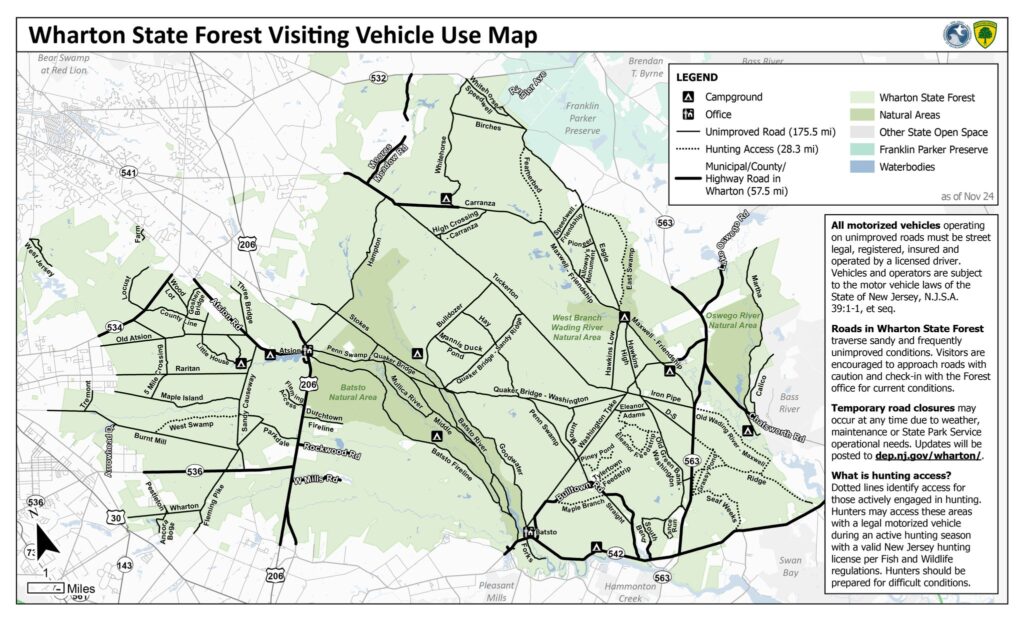
Well, looks like it’s all official. New Jersey Department of Environmental Protection (DEP) has published the Wharton State Forest Visiting Vehicle Usage Map, that I will continue to refer to as the VVUM. This map details 175.5 miles of unimproved roads, 28.3 miles of hunting access roads (by permit), and 57.5 miles of your typical paved municipal roadways. You may ask yourself what happened to the other 200+ miles? They are now off limits to motorized vehicles.
So what’s the deal? Over the last months and years there have been efforts to restrict access to these unimproved roads in order to preserve the ecosystem. A righteous cause, for sure. Unfortunately, however, I don’t think the execution will accomplish this goal. It only serves to remove access from law-abiding citizens seeking to enjoy the forest through motorized travel.
Numerous opportunities were offered for the community to provide feedback with very strong public and political support for keeping the roads open and enforcing the regulations that already exist. What’s interesting is that with these closures the regulations don’t even change. Access was already restricted to street legal, licensed and insured vehicles. Why not just impose the fines, and enforce without closing roads. You see, while those of us who will follow this map faithfully continue to follow the law, those who went off trail, rode ATVs and dirt bikes, dumped trash, left boats in the forest (yes, it happened), they will continue to do it regardless of what the map has on it, or not. The reduced milage of legal roads will now get increased traffic and greater impact which will no doubt be used in the future to close more roads.

In any case, it’s my hope there is sufficient public outcry that someone listens and reverses this decision. But in the meantime, the map is published and is being enforced. So please, if you are exploring the pines, have this map and follow it. We all know the bad apples tarnish the reputation of the off-roading and overlanding community… that makes it that much more important that those of us who live by the tread lightly principles champion them, promote them, and demonstrate them ‘louder’ than the trouble makers.

Georeferenced Map and GPX File
The DEP website has a georeferenced PDF you can import into Avenza. But for those who do not use Avenza I traced everything to the best of my ability into Gaia and exported to GPX. I did my best to be accurate, but use at your own discretion.


Add comment